March 1967 Electronics World
 [ Table of Contents] People
old and young enjoy waxing nostalgic about and learning some of the history of early
electronics. Electronics World was published from May 1959 through December 1971. All copyrights
(if any) are hereby acknowledged.
We take for granted most of the
technology that surrounds us. Unless you were alive 60 years ago at the dawn of
microelectronics and space flight, it would be difficult to imagine a world without
cellphones, desktop computers, color TVs, the Internet, and even satellite-base
weather forecasting. Everyone likes to make jokes about weathermen being no better
at predicting the weather than your grandmother's roomatiz[sic], but the fact is
that, especially for short-term (2-3 days) predictions, we get pretty good information.
As a model airplane flyer, I check the wind level forecast nearly every day to see
whether my model plane can handle it. AccuWeather's free hourly forecast is usually pretty
darn accurate for today's and tomorrow's wind - to within a couple MPH. A plethora
of ground reporting stations help improve accuracy, but data streamed from spaceborne
instruments are the real key. This story in the 1967 Electronics World reports on
some of the earlier imaging weather satellites. Amusingly, it also predicts the
possibility of someday controlling world weather with the satellites' assistance.
See all the available Electronics World articles.
Weather Surveillance by Satellite
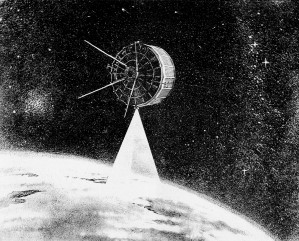 The new "cartwheel" Tiros photographs the
earth as the satellite rolls along like a wheel in a near-polar orbit.
By Joseph H. Wujek, Jr.Tiros, Nimbus, and successor
ESSA satellites are providing global weather information that may one day lead to
global weather control.
To a great extent, man has learned to use the forces of nature beneficially. A notable
exception is our inability to control those forces in nature which we know collectively
as weather. Weather plays an important part in social and economic well-being of
a nation. Agricultural output is strongly tied to the weather, as is the movement
of ships at sea, aircraft, and land transport. Indeed, commerce as a whole depends
to some degree on the behavior of the elements. In war as in peace, a nation's fate
may be decided by the perversities of the weather. The defeat of the Spanish Armada,
as well as the defeat of Napoleon's armies on the plains of Russia, were due in
large measure to severe weather conditions.
In view of all this, it is not surprising that meteorologists continually searching
for new tools to aid them in understanding the weather. With increased knowledge
of weather comes the ability to predict the kind of weather a region will experience.
President Johnson, when Vice-President and Chairman of the National Aeronautics
and Space Council, estimated the saving which our nation could realize if accurate
weather predictions were available only five days in advance. These yearly savings
include: $2.5 billion in agriculture; $45 million in the lumber industry; $100 million
in surface transportation; $75 million in retail marketing; and $4 billion in water
resources management. Beyond these dollar savings, we have the priceless savings
in human life which result when hurricanes, tidal waves, and the like are detected
in advance. Clearly, then, research into the nature of weather will have a profound
effect upon our welfare.
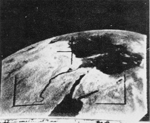 This view of the Nile River and its Delta,
the Red Sea, and the eastern Mediterranean was taken by Tiros III from an altitude
of 400 miles.
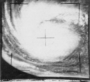
The vortex of the Hurricane Daisy photographed several year ago off the east
coast of the United States by the Tiros V satellite.
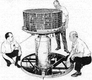
The Tiros VII being checked out prior to its launch into space.
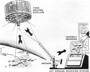
The APT ground receiving system uses fairly simple, inexpensive ground-based
equipment which employs conventional facsimile recorder.
Until early 1960, meteorologists were somewhat earth-bound in their measurements
of weather phenomena. True, aircraft and weather balloons were launched to measure
wind speed, barometric pressure, and other weather variables. Later, sounding rockets
were also used to obtain these measurements. But these measurements are somewhat
localized in that only a small region of the atmosphere or stratosphere is sampled.
And, as we know, weather is by no means predictable by immediate local conditions.
A storm front in the far reaches of Canada's Hudson Bay on Tuesday can create havoc
with cattle ranches in North Dakota on Thursday. Even with many remote weather stations
positioned at strategic points around the world, severe weather conditions can be
building up while unobserved by these stations. A system for weather surveillance
which could survey large sectors of the earth was urgently needed.
The Tiros Satellite System
The Tiros (Television Infra-Red Observation Satellite) series provides a partial
solution to this requirement. These vehicles, equipped with television cameras and
infrared (IR) radiometers, gather data for analysis by meteorologists within hours
after the observation. The first in the series, Tiros I, was launched from Cape
Kennedy on April 1, 1960. At this writing, ten Tiros satellites have been launched.
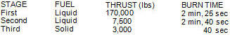
Table 1. Specs for Thor-Delta booster which launched Tiros.
The Tiros is an 18-sided vehicle, 22 inches high by 42 inches in diameter, weighing
about 300 pounds. Each of the 18 faces of the satellite is an array of solar cells.
These 900 solar cells furnish charging current for the 63 nickel-cadmium cells which
furnish power throughout orbit. Two 18·inch receiving antennas extend from the top
of the satellite and are used to receive ground commands. Four 22-inch telemetry
transmitting antennas are located on the underside of the package. Tiros I through
VIII had two vidicon TV cameras mounted on the underside of the satellite. Later
Tiros spacecraft have side-looking TV cameras mounted on opposite sides.
The Tiros series is put into orbit by the three-stage Thor-Delta launch vehicle.
Table 1 gives important specifications for this space booster. For some perspective,
recognize that jet engines used on modern commercial airliners have typical ratings
of 16,000 pounds thrust per engine. Hence, the first stage alone of the launch vehicle
delivers more thrust than ten of these aircraft engines. Launch vehicles have since
been developed which generate more than two million. pounds of thrust.
Tiros orbits range from 450 miles to 860 miles, with periods (time for one revolution)
of 90 minutes to 113 minutes, respectively. At the 450-mile orbit a region on earth
of 800 to 1000 miles in diameter is covered by one transmitted TV picture.
Tiros I through VIII were placed in a general east-west orbit, resulting in coverage
of about 25% of the earth's surface. Later Tiros launches resulted in a north-south,
or polar orbit. The polar orbit permits coverage of nearly all the earth's surface.
The polar orbit is also selected so as to be nearly synchronous with the sun. The
sun-sync orbit results in backlighting from the sun during the northward pass of
the satellite, producing high-quality photographs.
Tiros I-VII made use of a focal-plane shutter in conjunction with the two vidicon
TV cameras. Pictures are stored
on the tube face and converted to data bits for storage on magnetic tape or direct
readout by ground stations. Each orbit results in 64 pictures, or 32 pictures per
tape. Transmission of data to the ground station requires about three minutes. The
data transmission simultaneously erases the magnetic tapes for the next data-gathering
pass. The operation of the readout system as well as the timing of the picture-taking
sequence is accomplished by ground command. The ground command sets timers which
activate the camera system when the satellite passes over the region of interest.
Starting with Tiros VIII, a new system of data readout was used. The new system
is designated Automatic Picture Transmission (APT). Rather than construct a TV picture
line by line, electronically photograph the screen, and then store or transmit,
APT uses a system similar to that used by newspapers and the press services to transmit
photos. A facsimile recorder then reproduces the picture as received.
Ground receiving stations for Tiros are Wallops Island, Virginia; San Nicolas,
California; and Fairbanks, Alaska. Over-all direction of the Tiros system stems
from Goddard Space Flight Center, Greenbelt, Maryland. These stations are capable
of receiving data when the satellite draws to within 1500 miles of the station.
The received pictures are photographed by 35-mm camera for immediate analysis by
meteorologists. In particular, these photos reveal conditions of cloud cover as
well as the presence of hurricane conditions.
In addition to the TV camera, infrared radiometers measure the amount of reflected
and absorbed solar IR energy. The amount of IR energy absorbed and reflected determines
the heat balance of the earth and therefore affects the weather. The IR data is
transmitted and received as non-photographic data. This data is later reduced and
plotted on weather maps for analysis. While the IR data is not immediately useful
to meteorologists, it nevertheless provides a kind of long-range weather behavior
of our planet.
The initial design of Tiros called for a mission life of three to four months.
The first Tiros was operational for 2 1/2 months. Later Tiros vehicles operated
for well over one year. In the first three years of operation some 300,000 TV photographs
were transmitted. Tiros I completed 1302 orbits and relayed 22,592 pictures to ground
stations.
As seen in the accompanying photographs, Tiros has produced some startling results.
Of particular importance were other photos taken by Tiros III in Sept. 1961. These
photos revealed the build-up of Hurricane Carla. As a result of this early warning,
approximately 350,000 persons withdrew from the storm region involved and injuries
and loss of life were held to an absolute minimum.
Second-Generation Satellites
In addition to the ten Tiros launchings, two each ESSA (Environmental Survey
Satellite) and the Nimbus satellites that have been orbited.
The ESSA satellites are similar to the earlier Tiros systems and operate in the
"cartwheel" mode. ESSA I was launched on February 3, 1966 and carried two half-inch
vidicon TV cameras into a circular 460-mile-high polar orbit, having a period
of about 100 minutes. ESSA II carried two APT cameras into a circular 860-mile-high
polar orbit with a 113-minute period. NASA plans to keep two ESSA satellites in
orbit at all times. As one ESSA vehicle ceases to transmit, a replacement will be
launched. The ESSA satellites represent the operational system for which the Tiros
vehicles were the research and development packages.
The Nimbus represents a more sophisticated weather satellite system. In particular,
Nimbus is not restricted to photographing the earth during daylight. By means of
its high-resolution red radiometer (HRIR) system, night photos are obtained. These
photos appears as dark or light regions, depending on whether more or less heat
is radiated, respectively.
In addition to the HRIR system, three vidicon cameras are used. From an orbit
of 575 miles, resolution of one-half mile is possible. The APT system was also flown
on the Nimbus.
Nimbus I was moderately successful after launch on August 28, 1964. The second
stage of the launch vehicle did not burn as long as required, resulting in an elliptical
orbit of 252 miles perigee and 578 miles apogee, rather than the planned circular
575-mile orbit. The satellite transmitted many useful photos until a solar panel
locked and was thus unable to track the sun. As a result, Nimbus I ceased on September
23, 1964.
Nimbus II was successfully launched May 15, 1966, carrying HRIR, APT, and vidicon
systems. NASA plans to launch a Nimbus satellite approximately every 18 months.
These vehicles will serve to test new systems for improved weather observations
.
The Tiros vehicles and successors form the Tiros Operational System (TOS), which
is a joint undertaking of the U.S. Weather Bureau and NASA. In addition to the benefits
already listed, the Tiros system may provide scientists with new insight into such
phenomena as clear-air turbu-lence (CAT) and the nature of the "jet-stream."
Perhaps history will someday show that Tiros provided a significant advance toward
a goal we have desired, control of the weather. A system of sophisticated Tiros-like
satellites, relaying weather data to a central computer which directs corrective
(and as yet unknown) action to smooth the weather, is presently but a dream. But
the translation from dream to design to hardware has been foreshortened considerably
as our technology advances.
|